Follow-up report on the ITINERA2 research project
This document aims to provide a detailed description of the progress and current status of the ITINERA2 project, according to the different components involved in the development and deployment of the solution, as well as the procedure for data capture and visualisation for subsequent piloting and functional validation (sections 3.1, 3.2, 3.3).
In addition to these two components, the description of the development and integration of gamma strategies for the promotion of and adherence to physical activity is given in section 4.
Finally, the next steps to be addressed in relation to the current status and objectives pursued by ITINERA2 are set out (section 5).
2. Status of the project
This document is an update on the current status of the ITINERA2 project, which focuses on the implementation of an intelligent route based on IoT and gamification that offers a friendly environment and promotes healthy habits and the fight against loneliness in the older adult population in the semi-rural area affected by depopulation. After a first phase focused on a detailed initial analysis of scientific documentation of impact recently published in relation to the objectives of ITINERA2, the project has completed, in this second phase, the development of software necessary for its validation through its piloting in a relevant population group, having also agreed on the exact environment of implementation and being ready to start the collection of data that will allow the subsequent assessment of impact on the health of participants.
In this respect, the project has undergone a variation from the original proposal in terms of its location. Originally ITINERA2 was planned to be implemented in the council of Cangas del Narcea. However, after the results obtained in the municipal elections held last May, the participation of that council has not been possible in the end. Based on this, and after an assessment of existing alternatives, CTIC has proposed the deployment of the project in an environment with similar characteristics to the original, being Tineo the selected council.
The council of Tineo has a geographical location and socio-demographic characteristics practically identical to its original location, bordering on Cangas del Narcea to the south and being the second largest council in the Principality of Asturias (after Cangas del Narcea) and one of the lowest population densities with 25.1 inhabitants per square kilometre. In addition, it is also a semi-rural environment. Within the council of Tineo, ITINERA2 will be validated along the Senda Verde Tineo - El Crucero (P.R. AS-245), a route commonly used by the population of Tineo, which also has adequate accessibility features for the entire population. The path is approximately 2.5 kilometres long, and is practically flat along its entire length, with a paved surface.
Therefore, it is understood that, despite the modification with respect to the original proposal, the essential characteristics of the validation environment remain intact, thus not affecting either the characteristics required by the solution or the expected results.
However, linked to this change, it is necessary to indicate the consequence in terms of time delay with respect to the initial schedule derived not only from the need to locate a new location, but also from the need to submit the proposal to the local council and undergo an evaluation process by the latter. In spite of this, at present, the technical development has been completed, and we are in a position to proceed with its deployment and validation in the near future.
Additionally, it is worth mentioning that, besides the excellent reception by the local council, ITINERA2 will have the involvement of the Tineo Health School, which will play a fundamental role in the success of the project, through its commitment in terms of dissemination, recruitment and registration of participants. In this respect, the fact of having a local agent with knowledge of the population and the territory is considered essential for the population's involvement in ITINERA2.
In the following sections, the development process of the different components required by ITINERA2 for its correct functioning is described in detail.
3. Internet of Things (IoT) components
The whole solution, as far as IOT technology is concerned, is composed of different components that require elements installed on the route, as well as others carried by the user in the form of wearable technology (i.e. bracelets).
In terms of the elements involved, at the hardware and software level, the main components described throughout this document are
▪ The physical infrastructure (RFID modules), based on the Internet of Things (IoT). That is, the different automatic control points located along the route to carry out the monitoring of physical activity along the route.
▪ The software platform (Web Platform), which includes an internal management part and an interface part with which the users interact. This platform will allow both the registration of users and the collection of personal data needed to assess the impact of health in terms of quality of life; as well as the interaction, by the user, with respect to information, notifications, challenges and achievements associated with their physical activity, both individually and with respect to other people participating in ITINERA2.
The relationship between both components is shown, at a schematic level, in Illustration 1, describing both components in detail in the following section.
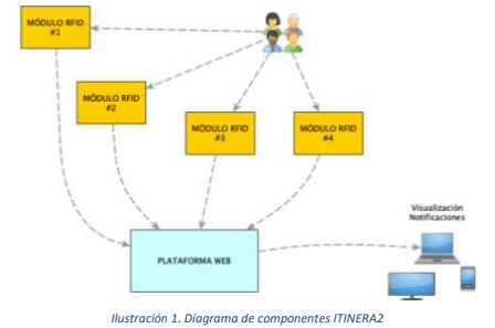
Specifically, as discussed in the following sections, ITINERA2 involves the deployment of four RFID modules responsible for capturing data from participants through individual identifiers in the form of bracelets that will allow the monitoring of users of the intelligent route.
The capture of information about the physical activity is based on the deployment of a network of sensors that capture anonymized information about the participants. This sensor network consists of four control points or RFID reader modules (i.e. Radio Frequency Identification), which act independently of each other, detecting the individual identifiers carried by the participants.
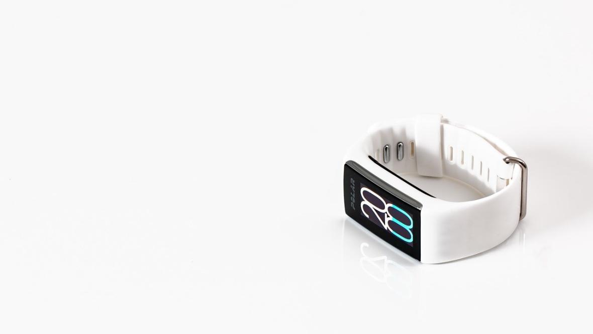
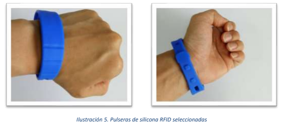
These individual identifiers have been developed by integrating passive RFID chips into an elastic silicon bracelet, which offers a high degree of comfort and no level of intrusiveness (see Figure 2), also allowing its specific use only at times when the route is used, if the user so wishes.
The transmission of data will be done through 3G communication, allowing monitoring to be completely automatic and without requiring any active and concrete action by the person to capture their information, thus maximizing the usability of ITINERA2.
The specific hardware components involved in the IoT components are described in detail below.
3.1 Components of the solution to be deployed
The selection of RFID technology is motivated by the privacy and user-friendliness implications of the project. The participants will receive a silicon bracelet, with the aforementioned coded chip embedded, allowing each of them to be uniquely identified.
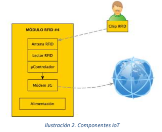
Each of the four RFID modules developed are integrated by different components to allow the functionality of RFID data capture, data processing and subsequent sending of data to the Web platform.
3.1.1 RFID Module
To capture the data from the wristbands, a solution based on a UHF (ultra high frequency) RFID reader has been implemented. Specifically, the M6E Nano1 has been selected, capable of transmitting a power of up to 27dBm and a circular UHF RFID antenna with 6dBi gain.
On the other hand, the reader is controlled by programming a micro-controller based on Arduino Uno rev32, using open source libraries available, which allows an agile communication between components and reliability in reading and processing data.
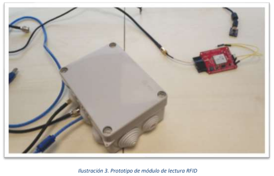
The selection of these components has been based on the results derived from the comparison of different devices, in prototype format (Illustration 3), in a simulated environment with similar characteristics to those of the selected path (outdoor space with a 2.5m wide path).
These modules will be installed on existing street lights along the selected route with an approximate separation of 500 meters between each one, allowing them to cover almost the entire route (Illustration 4). The lampposts will be used as a support for the placement of the modules, allowing their adequate location for the correct monitoring of the participants.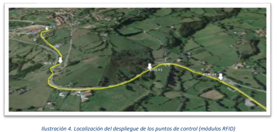
3.1.2 3G Communication
The micro-controller will be connected to a 3G module, which offers capabilities to transmit the information to the Web platform through GSM cellular technology (3G). This module is based on the SIM5320 controller, component3 that allows direct connection to the Arduino and communication with the rest of the system.
The programming of the Arduino has been done using the C++ language, again with open source libraries offered by the manufacturer. Based on the programming developed, once the RFID reader detects a bracelet, it extracts the unique internal identifier (EPC) and sends it, along with its internal RFID module identifier and a time stamp, to an MQTT4 queue (i.e. a message queuing mechanism) to which the web platform for monitoring the user's information is subscribed.
3.1.3 Bracelets
As indicated above, for reading and identifying users through the circuit, we have chosen to use silicon bracelets (Figure 5), which have an integrated and uniquely coded RFID chip. The bracelets selected have a design that is appropriate to the nature of the project, since the chip with the information is protected from external elements by the silicone itself and the installation area is separated from the person's wrist by small filaments that act as insulation (moisture and the composition of the human body make reading difficult) for proper reading, thus ensuring its proper functioning.
In addition, the bracelets are adjustable, allowing to cover the variability of the physical characteristics of the participants, presenting a size of 260mm long by 22mm wide. The selected chip is the Alien H3, widely used and with a high degree of reliability in similar cases (e.g. timing of outdoor sports events).
The bracelets will have two univocal codes, which will facilitate the correct management of the users: the EPC, or electronic product code, which will allow the codification of correlative integers from 1 to 300 in hexadecimal format and the TID, or univocal identifier of the manufacturer.
3.2 Software developed for the correct operation of the IoT components
As previously mentioned, the physical components deployed by the circuit will perform the data capture and later send it to the MQTT queue, so that the web platform will read the data sent by the different readers distributed by the circuit.
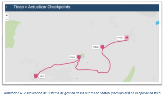
The web platform is a multi-device web application that allows the management of the circuits, the participants and the rest of the system functionality focused on the gamification. As an example, in Figure 6 shows an example of visualization in the platform developed, in this case, in the section of management of the RFID modules of the route.
The software is implemented with the programming infrastructure Meteor5, based on Node.js6, on a database in MongoDB7. The message queue that communicates the physical part (IoT devices) with the virtual one (Web application) is based on the subscriber/publisher model of MQTT, being the subscriber the Web application and the publisher the RFID data capture system. This software allows the communication between the different components to
cover the entire information collection and display circuit, from the beginning of its generation by the user, subsequent reading by the RFID modules, sending and processing to the web platform and display on personal devices (Illustration 7).

3.3 Software developed for user management
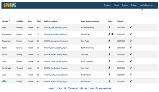
In addition to the public part and associated with the control of gambling options, the web platform includes a section to manage the people participating in ITINERA2. Anyone can apply for an account in the system, simply by filling out a form with minimum personal data and entering a password to control access. With this, it is possible to have a database (Figure 8) where each user appears associated with the identifier of his or her bracelet, to subsequently obtain individualized information that allows monitoring and personalized application of gamification strategies.
3.3.1 Role Management
Since the interaction with the Web platform will be carried out by different people and with different objectives, three types of users have been considered, distributed in the following roles:
- Public. Any person registered in the system is assigned this role by default. This role is associated with the participants, who will wear the bracelets to monitor their physical activity.
- Manager. This role offers privileges related to the management of ITINERA2. Specifically, with respect to the management of public users, being in charge of assigning the wristbands to the participants and writing down these assignments in the platform.
- System Administrator. Person responsible for creating and managing the data related to the circuits: description, distance between control points and configuration of the control points. In addition, the role of administrator allows the management of the roles of the rest of the people using the platform.
3.3.2 Participants management
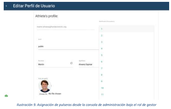
The management of the public users (participants) will be carried out by those persons identified as "manager", who will be able to make the assignment of the identifiers of the bracelets and the participants.
To facilitate the management of the system and the agility of the same one, the functionality has been incorporated that and the public users can create an account of autonomous form, although the system will not initiate the collection of data until the person identified like manager assigns an univocal identifier to him and a physical bracelet (Illustration 9), guaranteeing therefore the correct use of the platform.
The main functionality of the application is to transform the information about the physical activity of the participants and to offer data that can be easily interpreted by the users, encouraging participation through different strategies based on challenges and logos that depend on the data captured by the IoT devices.
Thus, once the system associates each participant to their bracelet and this one has physical activity, it calculates aspects such as their participation along the route, the time in completing the circuit (or its different parts) or its associated speed (obtained through the distance between the control points), fundamental aspects for the approach of achievements and the verification of the achievement of achievements that increase the adherence to the physical activity.
This gamification component is one of the fundamental parts both for the mentioned adherence and for the increase of the motivation to make use of the circuit, promoting not only the practice of physical activity, but also social relations by allowing gamification of behaviours both at individual and group level.
4.1 Individual and group participation
The challenges, achievements and dissemination of these will be applied both at the individual and group level, seeking collective participation in challenges. In this way, ITINERA2 offers users the possibility of belonging to groups (e.g. neighbourhoods, clubs, neighbourhood associations, institutions, etc.) with the aim of promoting social relations and adherence to one's own physical activity. However, in order not to distort the results, membership of a single group has been limited, although the person can change groups at any time they wish and join another group to achieve new challenges.
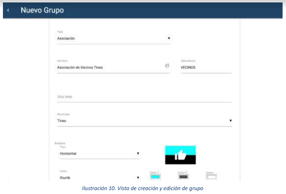
The groups, led by the person who proposes it, are totally customizable, being able to contribute information relative to their denomination and place (municipality), as well as defining a logo that allows to visualize of a fast and attractive form the collective results (Illustration 10).
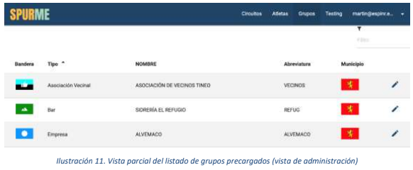
Apart from this personalisation, in order to motivate the group participation of the first people, a series of groups have been predefined to which the participants linked to existing entities in the municipality of Tineo can associate themselves (Illustration 11).
4.2 Challenges
One of the fundamental aspects, in terms of motivation, for the participation in the project, both at a collective and individual level, is the inclusion of challenges, individual and group, which the participants join.
The challenges have been established according to different parameters and measurements, which are obtained according to the participation along the route. The challenges included in ITINERA2 are:
- Activity time. It measures the level of individual participation. That is, days that the person or the members of a group are active and register activity in the circuit, rewarding the highest number of active days.
- Speed. It values the highest speed achieved in the circuit. At group level, the average speed among the members is calculated, positively valuing the highest average.
- Distance. It compiles the total distance covered by each participant, being the highest the most valued. In the case of groups, the average distance of its members is valued.
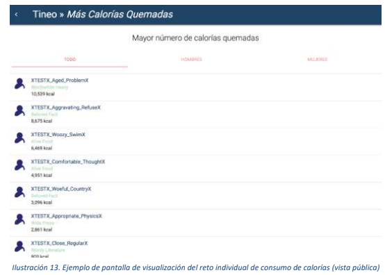
- Calorie consumption. The system makes a calculation based on an algorithm defined in the Adult Compendium of Physical Activities8 , which offers a coefficient (METs) relative to the level of physical activity (METs x Kg = Kcal/h). The highest total consumption of each participant is assessed, while at the group level the average of its members is assessed.
- Personal performance. In a similar way to the caloric consumption, there is another challenge where the physical performance of each person is valued, taking into account individual factors such as sex and age. For the calculation of this personal performance coefficient, the system is based on personal marks and age factors, calculated based on the specifications of the WMA (World Masters Athletic Association)9. The result is a numerical value that indicates an artificial level that can be compared between users. Higher values are positively evaluated. In the case of collective challenges, an average of the coefficients achieved by its members is made.
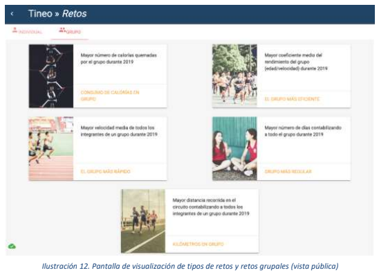
Within each of these challenges, the platform offers the possibility of viewing an individual classification (Figure 13), anonymously by user name, and group classification (Figure 14) with a comparison with the rest of the participants.
4.3 Achievements
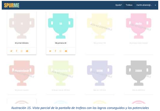
In addition to the challenges described, and associated with the gamification component, an option associated with people has been incorporated, emulating virtual achievements and granting recognition for having achieved them. These achievements are related to regularity (days of exercise), distance traveled and accumulated calorie consumption (Figure 15).
Some examples of these achievements are:
- Maratorian@ badge, upon completion of the first 42,195 kilometers
- My First Kilometer" trophy, when the person passes through the first two checkpoints
- Trophy "1000 Kcal burned", when more than 1000 Kcal are consumed.
4.4 Dissemination of achievements
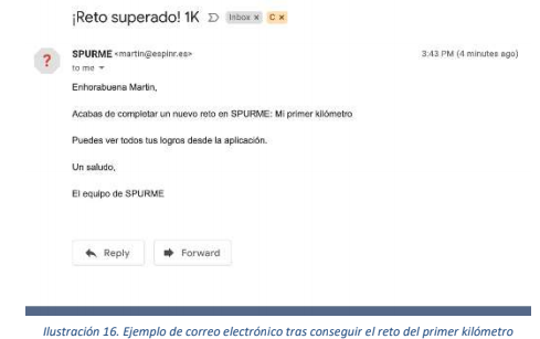
In addition to the direct and individual motivation of the participants through the challenges, a communication system has also been implemented that allows for the reception of an e-mail, for those who wish, that reports the achievement obtained and encourages them to continue participating (Illustration 16).
Additionally, and in order to obtain public recognition that helps to continue practicing physical activity, from the private part of the application (when the participant has introduced his or her credentials), where the collection of badges is shown, the option of sharing these achievements through the person's social networks is also offered in a simple way. In this way, at the base of each card that simulates the trophy there are icons that allow the promotion of the achievements obtained through accounts of: WhatsApp, Twitter, Facebook and email (Figure 17).

Once the different components that make up ITINERA2 have been developed and tested at the laboratory level and the environment for the implementation of ITINERA2 has been relocated, it is expected that in the following months the last two phases proposed in the schedule will be completed (i.e. Validation of the system by piloting on a representative sample of the population of interest and Evaluation of the impact on the improvement of health and generation of a report on the results).
To this end, within the framework of collaboration between CTIC Centro Tecnológico and the Tineo City Council, the Tineo Health School will play a fundamental role in promoting the dissemination of ITINERA2 among the population and in attracting the target population, especially those who already participate in its various initiatives. In addition, an official presentation of the project will be made by the Tineo Town Hall, increasing the visibility and potential participation of the population in ITINERA2. Likewise, the possibility of ITINERA2 being disseminated at a population level by Primary Care health professionals will be assessed, with special attention to those populations in which physical activity is considered beneficial, both at an intervention and prevention level.
Subsequently, data will be collected for subsequent analysis and generation of results to obtain conclusions.
6 Conclusions
Therefore, as shown throughout the document and indicated at the beginning of it, the ITINERA2 project has satisfactorily fulfilled the first three points of the proposed work plan (i.e. Design of the monitoring system, development of the gamma strategy and data consumption platform, and definition of the route and implementation of infrastructures), being able, once the scenario in which it will be implemented has been relocated, to validate the system in the real environment, initiating the monitoring of the users and, subsequently, evaluating the impact of ITINERA2 on their health.
In relation to the work carried out, it is considered that the software developed is adjusted to the needs of the target population that will participate in ITINERA2, while offering a high degree of personalization with respect to the preferences of the users through, for example, the creation and identification of local groups.
Similarly, the high number of challenges and achievements raised, as well as the possibility of sharing these achievements through social networks, is considered to generate a remarkable motivation and adherence with respect to other proposals that lack this component, and may facilitate the continuation of subsequent adherence after the end of the period of operation of ITINERA2.
In this sense, the hardware and software components have been tested at laboratory level, simulating conditions similar to those expected in the real environment, showing satisfactory results. Although ITINERA2 is proposed as a proof of concept, within the framework of uncertainty that R&D projects always imply, it is also expected that the system will work correctly once it is used in the chosen location.
In terms of implementation, although the impossibility of deploying the solution in the environment initially envisaged in the proposal has been a setback, especially in terms of time, the acceptance by the City of Tineo for implementation in its council has allowed this inconvenience to be overcome without affecting, in a particularly significant way, the schedule initially planned. On the other hand, as pointed out at the beginning of the document, the involvement of the Health School is considered a relevant aspect for the adequate development of ITINERA2 , since its local knowledge and power of attraction at a population level is especially remarkable, thus favouring citizen participation and involvement.
Once at this point, the last two phases of the work programme will be developed in the coming months, and empirical data will be obtained to evaluate the potential impact of ITINERA2 on the health of the participants.


